UK facing weekend washout - exactly where will face mega thunder and lightning
Brits are facing a horror weekend washout, with heavy rain and storms expected to sweep across huge parts of the UK.
After a surprising September heatwave, the weather looks to be returning more towards the seasonal norms. Whilst today and tomorrow will see temperatures remaining around the mid-20C in some places, after that, the weather will take a turn for the wet and windy.
From Sunday, and into early next, heavy rain and lightning and thunder are set to sweep in across much of the UK. A huge north-south band of rain and storm is due to creep up from the Atlantic Ocean and western Iberian Peninsula.
The V-shaped storm will cover much of the UK, Ventusky forecast, hitting Northern Ireland, Wales, and much of England, apart from the east coast. At its worst, as much as 10m of rain will fall in three hours from 4pm Sunday afternoon.
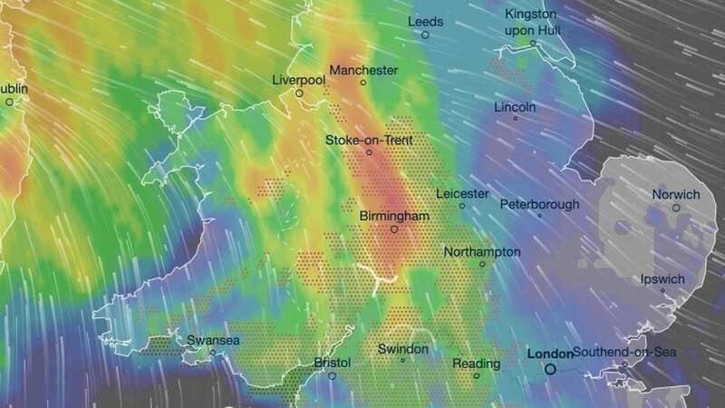
 The weekend washout is forecast to hit much of the UK (Ventusky)
 The storms will be at their worst at 4pm on Sunday (Ventusky)
The Met Office has warned that the weekend will see “thundery showers spreading north” that may just get worse on Monday. Forecasting for the weekend, they said: “Cloudy with outbreaks of rain across the north. Elsewhere sunny spells with scattered showers, these locally heavy with a risk of thunder. Showers becoming more widespread from the southwest later.
 Gales, snow and rain to batter country today with 80mph wind gusts
“Humid with thundery showers spreading north on Sunday. Further heavy and thundery showers likely on Monday, but it will turn drier and fresher from the south. Organised rain arriving Tuesday.”
Today will be clear skies for most of the country, with a band of rain stretching from Ireland, across parts of the northeast and northwest of England, and touching parts of Scotland. The band of rain will persistently cling on until tomorrow morning when it will slowly move southwards, before being replaced by the incoming storm that will soak the country from Sunday into Monday.
Today’s weather front has already lingered across the UK for a few days so far, and is set to continue. Alex Burkill, Met Office meteorologist also explained how it was helping create the conditions that led to warmer conditions in the south and fresher conditions in the north.
He said: “The weather front that’s been lingering across the UK for a few days now is going to continue for a little while yet. But as you can see it’s not just bringing some rain, it’s also forming the boundary between warmer air towards the south and something a little bit cooler, more fresher towards the north.
“It is going to try to push a little bit further northwards as we end the week and through the weekend it will actually start to break up and clear away. We will then have a bit of high pressure towards the north, but towards the south we’re going to drag in something perhaps thundery.”
Read more similar news:
Comments:
comments powered by Disqus