Met Office issues weather warnings with inches of rain set to batter Brits
Brits are braced to be hit by heavy rain which could result in power cuts and even leave homes and businesses flooded.
Downpours are forecast for most of the country throughout Monday, as the Met Office issues a yellow alert for Wales and the North projecting up to 80mm of rain - around a month's worth - which could fall in just a few hours. Northerners in particular are set to take a battering from the thick band which could also bring outbreaks of thunder.
Travel plans including flights may face disruption, power to homes could cut while the Environment Agency has marked the area affected by the rain band as being at risk of flooding. Meteorologists said the weather warning would last until 9pm on Monday evening, with the heaviest deluge set for South Scotland in the mid-afternoon.
"Rain is expected to develop across southwest England and south Wales on Sunday evening and spread northeast to affect many parts of England and Wales through Monday before easing and clearing into the North Sea on Monday night," A Met Office spokesperson said. "Within this larger band, a corridor of heavy, persistent and perhaps thundery rainfall is expected to develop.
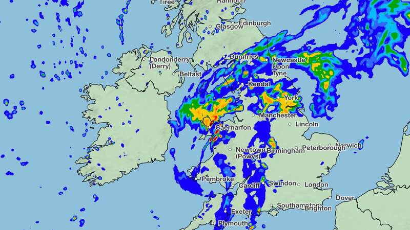
 Latest Met Office weather maps showed the heaviest rainfall would hit South Scotland by 3pm
"There is some uncertainty in the track of this heavier rain but 20-40mm of rain is expected to fall in many areas within the warning area, with a chance of 60-80mm falling in a few places, much of which would fall in three to six hours. At this stage, this very heavy rain appears more likely to fall over northwest Wales and northwest England."
 Met Office says UK will be battered by monster rain storm with 4 inches falling
The latest Met Office weather maps showed the heaviest rainfall would hit South Scotland by 3pm, before moving out to sea. The deluge, thankfully, is set to move on throughout the night.
Temperatures meanwhile will peak at a cool 17C to 20C, while East Anglia will see the warmest temperatures at 24C at around 5pm. The grim forecast follows what has already been a sodden August, while the Met Office revealed last month was the wettest July since 2009.
It made a stark difference to last summer, which experts branded as the driest July on record - resulting in major droughts which left parks across the UK parched and millions of Brits hit by strict hosepipe bans from water companies. This summer's damp weather was in part due to a stubborn jet stream, which shielded the country from the monster Cerberus heatwave baking parts of Europe with temperatures as high as 48C.
UK five-day weather forecast
This evening and tonight:
Showers in the north mostly fading but thundery outbreaks possibly continuing near Shetland. Cloud thickening elsewhere with heavy, perhaps thundery, downpours spreading across Wales and England.
Monday:
Persistent and heavy rain, with a risk of hail and thunder for some, moving northeast across England and Wales. Scotland and Northern Ireland experiencing sunny spells and scattered showers.
Outlook for Tuesday to Thursday:
An increasing amount of fine weather through the week with pleasant sunny spells and showers becoming fewer in number each day. Feeling warm in the sunshine as temperatures rise.
Read more similar news:
Comments:
comments powered by Disqus


