Terrifying new maps show when UK to be battered by 630-mile ice bomb
Brits are set for an Arctic blast this week with plummeting temperatures before a 630-mile ice bomb reportedly hits the country.
Many areas had a milder weekend but the colder conditions are about to return with temperatures plunging. Ominous winds are moving in from the east which at this time of the year are generally icy.
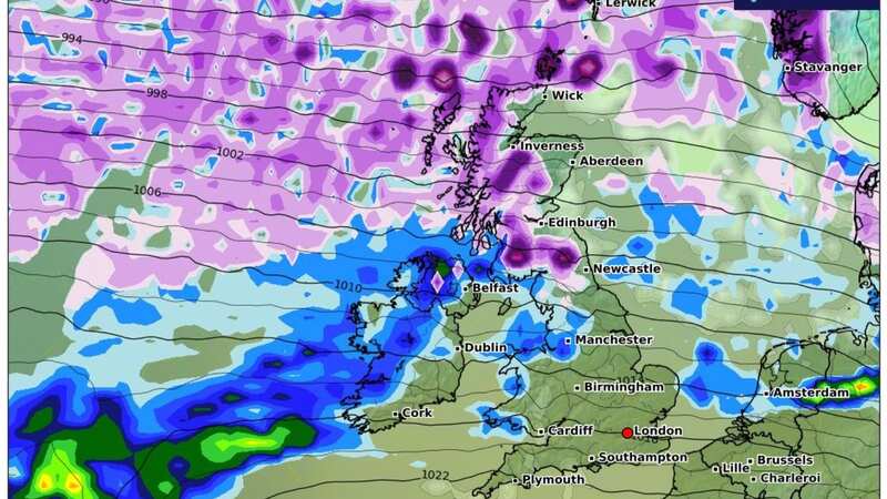
And weather maps from WXCharts show that the heavy snow is expected to come this coming Saturday, February 24, with the majority of the UK seeing flurries as the ice bomb covers a 630-mile area. It can be seen on the maps falling from the north of Scotland down towards Bristol with it landing at 10mm per hour in some locations.
Manchester, Sheffield, and Edinburgh are set to be the worst affected, seeing the deepest snowfall, but southern areas including Birmingham, Oxford, and Cambridge will also see a reasonable-sized covering. Scotland will see the heaviest snow falling in an icy snap that is set to carry on until the end of the month.
 A map shows the snow clouds moving in by the end of the week
Temperatures, according to the maps, are expected to start dropping noticeably by midweek and could be as low as -5C in northern areas. But the Met Office is more cautious about how cold it will get and has said there is a lot of uncertainty about how the weather will play out over the coming weeks.
 Gales, snow and rain to batter country today with 80mph wind gusts
Met Office forecaster Annie Shuttleworth looking ahead said: "We are then expected the high to build across eastern areas of the UK, there is some uncertainty (...) but the general details are for a large area of high pressure to develop to the east of the UK and a large area of low pressure to develop to the west of the UK. Where exactly that high and low in relevance to the UK is, is a little bit uncertain and unfortunately as the UK is a lot smaller in comparison to that high and low pressure it will mean that there is a big differences to the weather depending on where it sits."
 Large areas of the country are set to see snow
And the Met Office forecast from February 16-25 reads: "This period will likely begin with cloud and rain moving away from east or southeast Britain to give a brief more settled spell with patchy overnight fog or frost. How long this drier weather lasts is uncertain, as mild, cloudy conditions with outbreaks of rain or drizzle are expected to return from the west or southwest either later in the first weekend or early the following week.
"Further into the period, spells of wet and windy weather remain likely, these probably more focused than usual across south and southwest UK, while there is a higher chance of colder, brighter interludes across the north. Towards the second weekend, there is a chance that less changeable conditions may become more widely established."
Read more similar news:
Comments:
comments powered by Disqus