Cold health warnings over heart attacks as temperatures plunge below zero today
Elderly people and those with a history of medical conditions are feared to be at risk of strokes and heart attacks as the mercury tumbles heading into the weekend.
Brits have shivered in colder temperatures this week as the wet weather gave way to colder conditions, dropping sub-zero overnight. But yesterday the UK Health Security Agency (UKHSA) issued a yellow alert as a plunge of Arctic air arrived in the UK and extended it to midday today. As well as the cold weather, the Met Office’s forecast for today shows cool and dry conditions, staying often cloudy as well as the odd spot of drizzle. Light winds are expected with rain later in northern Scotland.
Dr Agostinho Sousa, head of extreme events and health protection at UKHSA, said: “The temperatures we will see leading into the weekend can rapidly have a serious impact on the health of those over the age of 65 and those with pre-existing health conditions as it increases the risk of heart attacks, strokes and chest infections. It is therefore vital to check in on friends, family and neighbours to ensure they are well prepared for the cold weather next week.”
Yesterday, all regions of England were placed under a yellow alert. Previously, five regions were under an amber alert and four under a yellow alert. With cool conditions in charge and the potential for snow and ice for some from Sunday onwards, travel plans could be impacted.
It comes as the Met Office warned of "disruptive snow" with an arctic airmass set to bring cold air to the UK next week. Deputy chief meteorologist David Hayter said a northerly airflow will bring arctic air to the UK from Sunday, with snow showers focused around Northern Ireland and northern areas of .
 Gales, snow and rain to batter country today with 80mph wind gusts
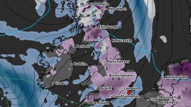
 Weather map for Friday, January 12 (WXCHARTS)
He added: “While the initial snow risk from Sunday onwards is looking most likely to be coastal areas in the north of the UK, including North Sea and Irish Sea coasts, there's an ongoing likelihood of some disruptive snow through the middle to latter part of next week. What we're keeping an eye on for this disruptive snow is where exactly this milder air from the southwest bumps into the cold air that will be in place over the UK.”
A Met Office spokesperson added: "Cool and largely dry conditions will persist for much of the UK over the coming days, with below-freezing conditions overnight, and daytime temperatures often not getting above 5C for many. From Sunday and into the start of next week, a plunge of cold Arctic air will move in from the north, dropping temperatures further and increasing the risk of wintry showers, especially for those in coastal areas in the north. As we move through next week, cold conditions are likely to persist, with an increasing chance of significant snow and ice for some, though details are still being determined."
Read more similar news:
Comments:
comments powered by Disqus