Storm Henk named by Met Office as 'danger to life' warning issued
Brits are being warned of Storm Henk that will bring a spell of very strong winds, causing disruption to travel and power supplies with an amber alert in place, says the Met Office.
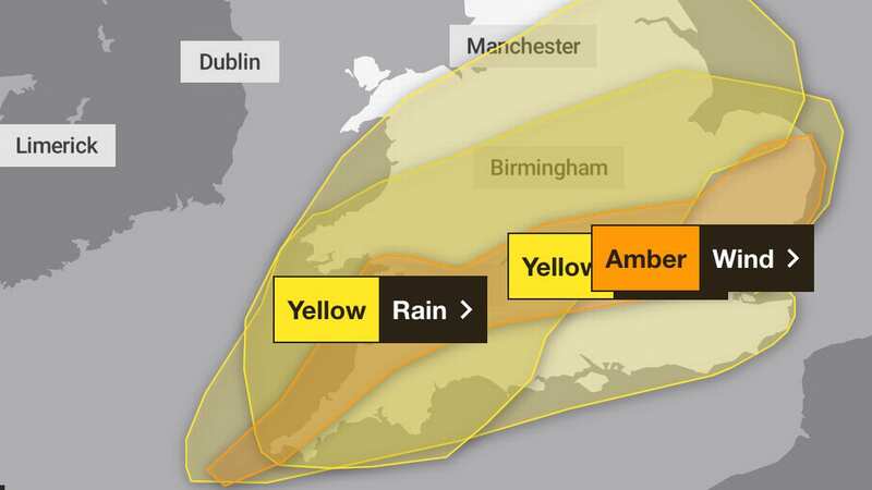
Storm Henk, which is forecast to bring gusts of up to 80mph to parts of the UK, is in place from 10am today and will run until 8pm. The forecaster has issued the amber weather warning for parts of southern England, the Midlands, East Anglia and Wales during today.
The gusts of up 70 to 80mph are likely on exposed coasts in the west, with gusts of 50 to 60mph expected inland. A low pressure system is coming in from the Atlantic over the coming days which is bringing the unsettled weather with strong winds and rain. By the end of the week it is expected to have moved on with drier conditions that will also see a significant drop in temperatures.
 The amber and yellow warnings for the UK (Met Office)
What to expect with amber warning
- There is a good chance that power cuts may occur, with the potential to affect other services, such as mobile phone coverage
- Probably some damage to buildings, such as tiles blown from roofs
- Longer journey times and cancellations likely, as road, rail, air and ferry services may be affected
- Flying debris is likely and could lead to Injuries or danger to life
- Some roads and bridges likely to close
- Injuries and danger to life is likely from large waves and beach material being thrown onto coastal roads, sea fronts and properties
Large swathes of the country will also be drenched after heavy downpours today - with more than half an average month's rain to fall in hours with a yellow weather warning in place for rain. Up to 50mm could come, the Met Office says, which would be more than half of an average January's total precipitation for most parts of the UK. In Birmingham, one of the cities affected by the weather warning today, around 70mm of rain is expected throughout the whole of a typical January. Manchester, also affected, sees around 77mm each January.
 Heavy rain is also expected for large parts of the country (Steve Taylor/SOPA Images/REX/Shutterstock)
Met Office Chief Meteorologist Paul Gundersen, said: “Further wet and windy weather is forecast for the UK this week. Our latest analysis of the forecast shows an increase in the likelihood of very strong wind gusts across parts of southern Wales and England which is why we have issued this Amber warning this morning and named Storm Henk.
 Gales, snow and rain to batter country today with 80mph wind gusts
“Storm Henk will initially bring very strong winds to the southwest of England and Southern Wales, with gusts of up to 80mph possible. As Storm Henk moves north-eastwards across the south of the UK through Tuesday the strongest winds will also move eastwards, across the south Midlands, Home Counties and East Anglia through the afternoon and evening.”
And Met Office forecaster Jonathan Vautrey stated: "At the moment it does look like a lot of that rain will push across the vast majority of England and Wales, turning widely wet once again throughout Tuesday. Parts of south-eastern, eastern Scotland should hold on to some slightly brighter periods for the bank holiday but it is going to be very wet and windy once again for the Northern Isles, Orkney and Shetland."
There is also a yellow weather warning for wind stretching across the UK, from west Wales to Kent that runs until 9pm tonight. Some travel disruption is likely as the heavy rain is set to fall on ground that is already saturated as it comes after recent wet weather.
There will be a north-south contrast in temperatures ranging from between 8C to 13C but it will feel chillier in the wind and rain. The weather warning concerning rain states: “Over the warning period, 15 to 30mm rain is likely to fall fairly widely, with a few places seeing 35 to 50mm. The worst of the rain should clear southwestern areas of England and South Wales by around the middle of Tuesday but could last into the evening across the north-east of the warning area. Strong winds will affect parts of the area.”
Read more similar news:
Comments:
comments powered by Disqus


