New maps show exactly where and when 'triple' storm will hit Britain
Britain will be hit by a 'triple' wave of storms soon as wet and windy conditions continue to dominate, according to the latest weather maps.
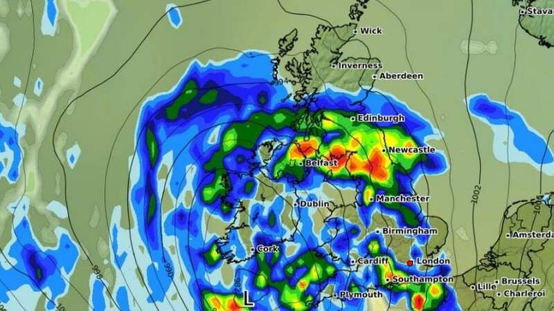
New forecasting models from WXCharts show large fronts of heavy rain moving over the UK on Monday 18 March, leaving much of the country drenched.
The harsh weather front sweeping in from the Atlantic will begin around 24 hours before, beginning a series of three quick storms.
Torrential downpours of 10mm per hours are forecast in some of the worst affected areas, while showers will be widespread.
Areas likely to be especially badly hit include northern England, border areas of Scotland and the southwest. Wales and the southeast are also likely to experience some heavy rain towards the end of the day.
 Gales, snow and rain to batter country today with 80mph wind gusts
 Weather map for Monday 18 March (WXCharts)
The stormy forecast comes after meteorologists tipped the rainy picture which led to a record wet February to last into the middle of March. The Met Office's long-range forecast for Sunday 10 March to Tuesday 19 March reads: "Rather cloudy across much of the UK on Sunday with outbreaks of rain for many areas, some of this heavy at times. This rain will probably clear to the west or southwest later in the day, with mainly dry conditions developing for most areas at the start of next week.
"From midweek onward, rain or showers begin to become more likely in the south at times, perhaps accompanied by strong winds in places. It will probably stay drier and brighter across the north, although still with a few showers in places. Temperatures are most likely to be close to normal overall, but mild at times in the south and perhaps a little colder than normal in the north."
A recent blog from forecasters MetCheck also warned that there is "little indication that things are going to settle down" over the next few days with a "changeable theme continuing". However, this may be interrupted by some drier, sunny spells.
In the meantime, Met Office spokesperson Andrea Bishop has told the Mirror that highs of 15C possible for London on Friday, though overnight lows could dip to -3C in parts of the country. The weather will remain unsettled and cooler until Wednesday when a short milder spell begins, she said.
Read more similar news:
Comments:
comments powered by Disqus