Exact time and place weather maps forecast massive snow blast hitting Britain
Weather maps show clouds heading into the UK as the country is hit by an Arctic blast with freezing temperatures.
After the strong winds today, the country is likely to have some mild temperatures for several days which could reach the mid-'teens. But then after the weekend, there is another possibly long icy spell on the way.
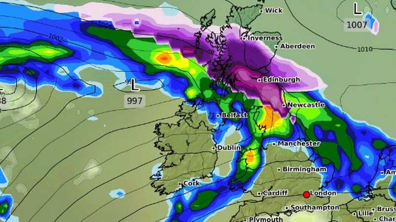
WXCharts show subzero temperatures and heavy snow in the north of the UK with around 25 centimetres projected on February 7. Around midday next Wednesday, the snow will have moved in from the west, bringing several centimetres of snow per hour across most of Scotland and north-east England, including Newcastle.
Then by 6pm on Wednesday there is a fairly similar chart with snow continuing to fall in Scotland and easing in the north east of England. But overnight into Thursday there could be as much as 25 centimetres landing as many northern areas see flurries.
 Snow is being predicted for February (PA)
And the long-term outlook remains wintry with a map showing snow for central and western Scotland, as well as patches in north west England on February 12, while by February 16 it could be as low as -5C in Scotland along with further heavy snow. At the same time, the Met Office has warned that freezing snow is a possibility in some areas.
 Gales, snow and rain to batter country today with 80mph wind gusts
 A chart for 12pm on February 7 (WXCharts)
"It can produce striking effects, as the rain drop spreads out momentarily across the surface before it freezes, encasing the surface in a layer of clear ice,” the national agency stated. “However, it is not just these eye-catching scenes that the freezing rain can bring; the weight of the ice can sometimes be heavy enough to bring down trees and power lines, and the glaze of ice on the ground effectively turns roads and pathways into an ice rink. The freezing rain can also prove extremely hazardous for aircraft."
 Snow clouds over the UK at 6pm on February 7 (WXCharts)
 The outlook for February 12 at midday (WXCharts)
But the Met Office is cautioning against fear of a Beast from the East, and spokeswoman Nicola Maxey told the Mirror the outlook is unclear. She said: "At the moment the most likely scenario for the first part of February is for fairly changeable and unsettled and towards the middle of the month there does appear to be potential for some colder spells.
"But it’s really not possible to look that far into the future and say if that involves snow, or whether the temperatures will be just a little below average or worse than that. When you’re looking at long-range forecast the chaotic nature of the atmosphere comes into play so smaller events over the Atlantic have the potential to have significant impact on the weather here in several days.
"While you can talk about the general feel of the forecast with some accuracy looking that far ahead it’s harder to come up with local detail, like you’d expect in shorter range forecast. There’s certainly the potential for some colder spells as we go through February but at the moment it’s still too far off to give detail."
Read more similar news:
Comments:
comments powered by Disqus