Britain battered by 106mph gusts from Storm Ingunn with wind warnings issued
Brits have been battered by gusts of more than 100mph from a ‘weather bomb’ and there are warnings of further strong winds ahead.
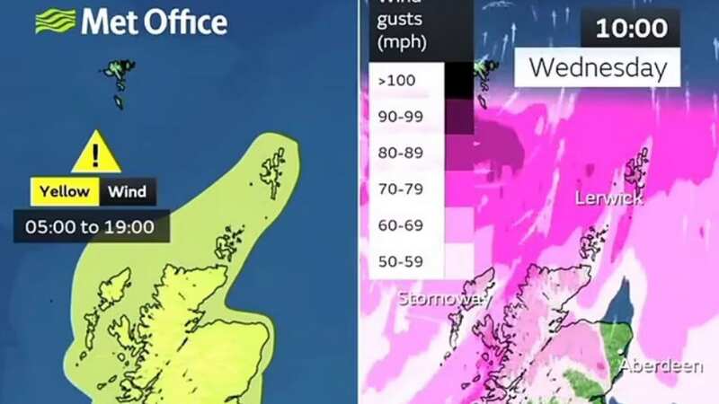
The Met Office has yellow warnings in place for Scotland and parts of northern England and Northern Ireland today as Storm Ingunn hits. Named after the Norwegian Meteorological Institute the storm has formed from a low pressure system that has swooped in from the Atlantic and is bringing the strongest winds to the north of the UK.
“Just had a wind gust of 106mph in Aonach Mor,” tweeted BBC weather forecaster Carol Kirkwood. And BBC weather said: “#StormIngunn - named by Norweigen Met service - is undergoing explosive cyclogensis in the N. Atlantic right now (basically intensifying very rapidly). Bringing very strong winds to the N & W of Scotland with gusts of 75-85mph.”
It became a weather bomb with its central pressure having fallen by up to 50 millibars over 24 hours. “A 'weather bomb' is an unofficial term for a low pressure system whose central pressure falls 24 millibars in 24 hours in a process known as explosive cyclogenesis,” states the Met Office.
 The Met Office has issued yellow warnings (Met Office)
“Rapid acceleration of air caused by the jet stream high up in the atmosphere can remove air from the column, reducing its weight so causing pressure to fall at sea level.”
 Gales, snow and rain to batter country today with 80mph wind gusts
The Met Office yellow warning for wind runs until 5pm today except for the north of Scotland where it is extended until 7pm, and people are being warned that it is likely to cause travel disruption.
What to expect in yellow warning
- Some bus and train services affected, with some journeys taking longer
- Delays for high-sided vehicles on exposed routes and bridges and damage to trees is also possible
- Some delays to road, rail, air and ferry transport expected
- Some short term loss of power and other services
- Coastal routes, sea fronts and coastal communities will be affected by spray and/or large waves
As well as gusts of 106mph at Aonach Mor, there are also winds of 70mph on South Uist, 60mph at Stornoway and 46mph in Edinburgh so far. ScotRail warned of speed restrictions and cancellations to trains with replacement buses running on routes between Glasgow and Oban; Inverness and Wick; Inverness, Tain and Invergordon; and Perth and Inverness.
 The winds are coming from Storm Ingunn (Met Office)
Met Office forecaster Clare Nasir said: It is a very windy day today with wind warnings in force across northern parts of the UK. In the far north of Scotland it could reach through the day 75mph to 85mph associated with this weather front coming in from the north west. Further west covering the rest of Scotland down towards Cumbria and Northumberland, north Yorkshire, Tyne and Wear as well as the far north of Northern Ireland, gusts inland 45mph, on the coast and over the higher ground up to 65mph, so some damaging winds through today.”
 A low pressure has been sweeping in from the Atlantic (Met Office)
Looking further ahead, Brits look set to be in the grip of cold next week as we finally leave January behind. The Met Office said in its long range forecast: “There is a chance colder conditions could then become established more widely during the first full week of February, with increased chance of wintry weather, especially northern and central UK, should Atlantic cloud and rain be forced to track across the south of the country.
“Equally, similar conditions to the start of the period could well prevail; confidence is low at this range in the weather type which will become most dominant. Following on from earlier in the month, either the period will start changeable with temperatures overall around average and a northwest to southeast split in conditions, or colder conditions will have become established, mainly across the north.
Read more similar news:
Comments:
comments powered by Disqus