Weather maps show polar blast to hit UK with snow hours after Christmas
Brits are set to be hit by a freezing polar blast with maps showing ice and snow just hours after Christmas Day.
After a bitterly cold start to December the weather has turned milder which had dampened expectations of a White Christmas. But this week is now expected to get colder as it progresses and some snow could fall on lower ground in the northern areas.
The main battleground is between air moving down from the Arctic and a warmer front coming from the south which is likely to mean milder conditions in mid-week before the icy weather hits. A BBC forecast suggest snow and blizzard conditions for northern parts of the UK on Thursday and then following that into the weekend the temperatures are expected to be milder again.
For Christmas Day, weather maps from WXCharts show icy conditions again in the north and the mercury could drop to as low as -4C overnight in the north of the UK. Northern England and Scotland may experience wintry showers and up to two inches of snow in the Highlands.
At lower levels, some towns and villages could see up to two millimetres of ice rain per hour as temperatures plummet below 0C. While southern England is not expected to see any snow or rain, temperatures will remain chilly as cities such as London and Birmingham could have temperatures ranging between 0C and 4C.
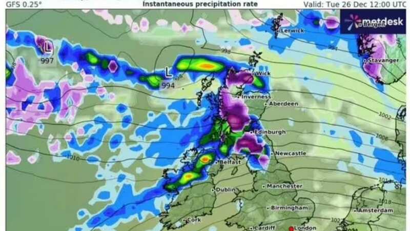
 Gales, snow and rain to batter country today with 80mph wind gusts
 A weather map for Boxing Day (WX CHARTS)
As technically only a snowflake on Christmas Day would make it a white Christmas, the Met Office has stated that this would not be unusual. And Deputy Chief Meteorologist, Helen Caughey said that there could be “wintry showers” in the north.
She stated: “Wintry showers continue to feed in across the north and here colder conditions also mean rural areas will likely see a frost on Christmas morning. As we begin Christmas day, wintry showers initially feeding in across the north in the colder air mass would technically make it a white Christmas, as we only need to see a single flake falling.
 A map showing the snow clouds moving in over Christmas (WX CHARTS)
“Elsewhere, while it is likely, at first, to be mostly dry there is the potential for rain approaching from the west later on. As this moves east, we may see rain turning to snow, at least over high ground.”
The Met Office has said it is “unlikely” that the UK would see any “widespread or settling snow” on Christmas Day. Ms Caughey added: “Although technically it might be a white Christmas, don’t get your hopes up for a picture-perfect white landscape.” The definition of a white Christmas is when one snowflake is observed falling in the 24 hours of December 25 somewhere in the UK.
Read more similar news:
Comments:
comments powered by Disqus